|
|
Post by pjaye on Sept 27, 2021 0:53:35 GMT
The other day when there were protests in Melb someone on a reddit thread linked this website where you can see all the planes in the sky in real time, who they are, the flight path etc. I didn't even know we could do this! I had a look at the skies above me just now: 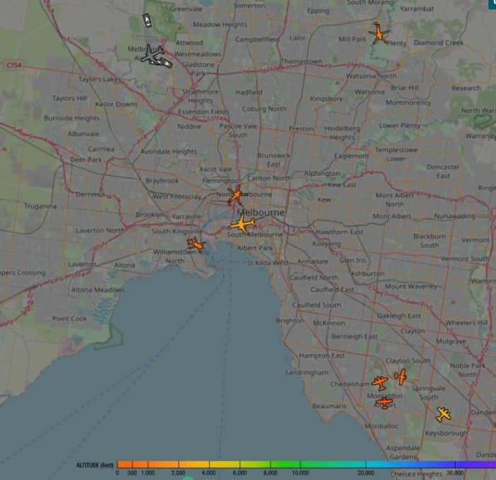 two police choppers, some light aircraft & a commercial passenger plane, then I zoomed out to look at all of Australia.... 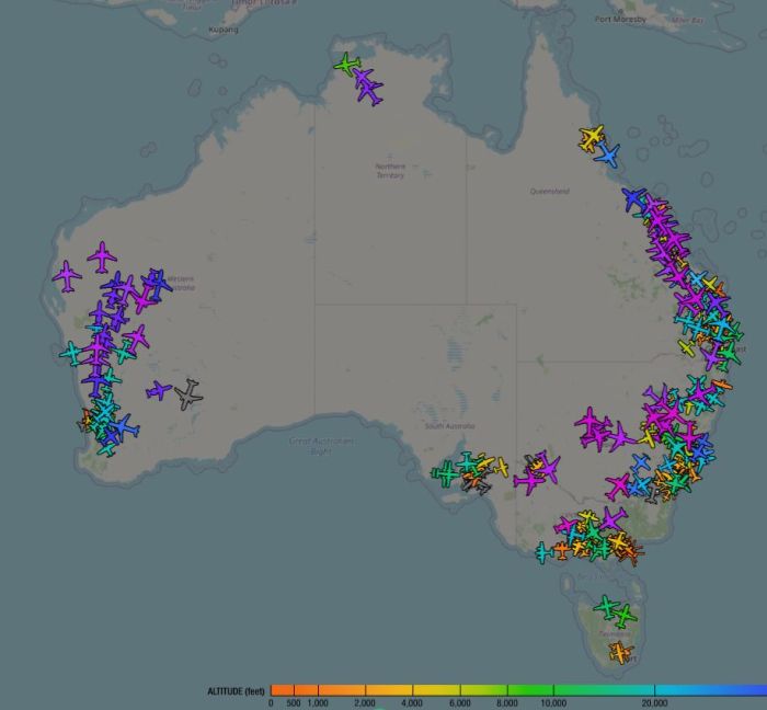 Considering out international borders are closed, that still a lot of planes! I was surprised. Then I looked at the world map... 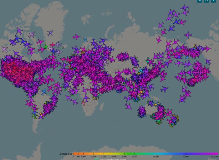 WTF? That's a LOT of planes in the sky at any one time! I had no idea that there are so many up there at any one time. I have a new admiration for air traffic controllers - it's not like there's any traffic light up there! LINK so you can see what's above you, you can click on each plane to see what type of plane it is, it's flight path etc. |
|
|
|
Post by KelleeM on Sept 27, 2021 0:57:07 GMT
Holy moly! That’s fascinating, thanks for sharing!
|
|
|
|
Post by Scrapper100 on Sept 27, 2021 1:01:21 GMT
We can look at local ones as well but have found that many county owned planes like police or fire not all have transponders same with military that fly around here or at least not all show up on the free apps. It’s really fun to see their flight paths. We watch them during fires and see where they are getting water and such.
|
|
|
|
Post by pjaye on Sept 27, 2021 1:04:07 GMT
I thought so - and if you have someone you know on a flight, you can look up their plane and see where it is in the air at any time. The reddit thread I was on was quite funny - one person was saying "there must be something going going on in Thornbury because there's several choppers overhead" and the other poster linked this website and said "no there's not - no choppers anywhere near you"  |
|
|
|
Post by ntsf on Sept 27, 2021 1:18:47 GMT
on 9/01 they had maps on tv of the us with no planes. you can look at ships on similar maps.
|
|
|
|
Post by librarylady on Sept 27, 2021 1:30:33 GMT
I shared that link with my family about a week ago. I am in the Dallas/Fort Worth area and the skies are full of planes. 103 in the screen right now. My niece lives in Muncie, Indiana and the day she checked her skies, they had 2 Piper Cub planes in the air.  |
|
|
|
Post by Spongemom Scrappants on Sept 27, 2021 1:40:16 GMT
I think I've seen this site before, but I forgot about it. It's fascinating in a weird sort of way. I'm in a relatively rural area (small city of about 23,000) and we have a small airport that handles mostly single engine planes. My house is relatively close to that small airport and we see mostly private planes in the sky fairly often. I could actually track a few friends' planes this way!
|
|
|
|
Post by pjaye on Sept 27, 2021 1:59:48 GMT
I am in the Dallas/Fort Worth area and the skies are full of planes. 103 in the screen right now. 103 - that's quite a few! Obviously I knew there were quite a few planes up there, but I had no idea of just how many there really are. It was a surprise to me...also very surprising that there aren't more accidents. |
|
|
|
Post by librarylady on Sept 27, 2021 2:06:31 GMT
I am in the Dallas/Fort Worth area and the skies are full of planes. 103 in the screen right now. 103 - that's quite a few! Obviously I knew there were quite a few planes up there, but I had no idea of just how many there really are. It was a surprise to me...also very surprising that there aren't more accidents. and we are up to 158...including 5 helicopters.. Busy Sky here! |
|
|
|
Post by Crack-a-lackin on Sept 27, 2021 2:20:21 GMT
This site, and similar apps, really helped me to manage my fear of flying. There are so many planes in the sky at any one time, and seeing it in real time was the proof I needed to convince myself it’s safe. I still don’t love it, but I can manage my fears now.
|
|
|
|
Post by revirdsuba99 on Sept 27, 2021 3:17:45 GMT
Ten miles from Newark International Airport, we got PLANES!!
Small local Linden Airport where the ABC News helicopter lives is right up the road with other helicopter and small planes.
Across the river JFK and Laguardia. Lots more PLANES!!
|
|
|
|
Post by katlady on Sept 27, 2021 3:30:47 GMT
If you have an iPhone, you can ask Siri, "What planes are overhead?"
Right now, I have one Southwest airplane, 737, flying in my area. It gives the flight number too.
|
|
|
|
Post by katlady on Sept 27, 2021 3:33:38 GMT
and if you have someone you know on a flight, you can look up their plane and see where it is in the air at any time. I do this all the time with family members when they are flying. LOL! |
|
|
|
Post by jemmls4 on Sept 27, 2021 3:36:48 GMT
Try the app Flightradar24. My brother is a commercial pilot and told me about it. It even tracks small planes and balloons.
|
|
|
|
Post by AussieMeg on Sept 27, 2021 3:45:39 GMT
That's really cool, thanks for sharing! Just as I was reading this, a small plane flew overhead. I was able to see that it is a 2007 Diamond Twin Star rego VH-IUU.  I assume it's on its way back to Lilydale airport. A few weeks ago someone at work gave me a similar link for shipping vessels. I was stunned when I zoomed out and saw just how many vessels were in the waters around Australia. There are so many shipping delays at the moment, and vessels that were supposed to have docked at Freo were just hanging around in the Great Australian Bight off the coast of South Australia. It was pretty cool to be able to track all the vessels that had our stock on them |
|
|
|
Post by AussieMeg on Sept 27, 2021 3:47:40 GMT
That's really cool, thanks for sharing! Just as I was reading this, a small plane flew overhead. I was able to see that it is a 2007 Diamond Twin Star rego VH-IUU. I assume it's on its way back to Lilydale airport. Nope, he's not going to Lilydale, he's headed out past Dixons Creek and is now chucking a U-ey towards King Lake! This is fun! |
|
|
|
Post by AussieMeg on Sept 27, 2021 3:51:00 GMT
I just saw two planes that looked like they were about to have a head-on crash, but luckily I was able to check the altitude..... one was at 40,000 feet and the other was at 4,100 feet! (Why do they use imperial measurements in aviation?)
|
|
ModChick
Drama Llama
 True North Strong and Free
Posts: 5,062 
|
Post by ModChick on Sept 27, 2021 3:55:57 GMT
Try the app Flightradar24. My brother is a commercial pilot and told me about it. It even tracks small planes and balloons. Ohh this one I like, easy to navigate and see the route. Very cool. Downloaded the app. Didn’t realize the amount of planes either, like OP knew there are a lot but this is just wow. I’d say air traffic controller, most stressful job ever ✈️ 🎮 😳 ETA: We are right under a flight path and love that I just looked up a plane coming from Vancouver and now I can see the lights of the plane out my window. Fun!! |
|
|
|
Post by **GypsyGirl** on Sept 27, 2021 4:27:12 GMT
The most unique use of FlightRadar I've seen was a couple of years ago. There were several SEC football teams interviewing for new head football coaches. Many of the schools have a plane and often use them to fly the coaches in for interviews (or the search committee flies to the coach). Die hard fans get the tail number and track the flights, which gives them a pretty good idea of who is in the running for the job! DH's school has gotten wise to that though and had their tail number blocked. Party poopers!  |
|
tanya2
Pearl Clutcher
Refupea #1604
Posts: 4,423
|
Post by tanya2 on Sept 27, 2021 5:04:17 GMT
I love that flightradar app, it's so fun to use! Especially during covid when it was really rare to see a plane in the sky
|
|
wellway
Prolific Pea
Posts: 8,769
Jun 25, 2014 20:50:09 GMT
|
Post by wellway on Sept 27, 2021 5:25:31 GMT
You can zoom right in and see what runway a plane lands at.
It was handy to me to know the school trip out of Barcelona had left on time and pick up would not be delayed.
|
|
|
|
Post by pjaye on Sept 27, 2021 5:29:03 GMT
just saw two planes that looked like they were about to have a head-on crash, but luckily I was able to check the altitude..... one was at 40,000 feet and the other was at 4,100 feet! (Why do they use imperial measurements in aviation?) I was looking at it last night and there were a couple of RFDS planes flying...made me wonder who they had on board. I get a lot of choppers in my area, now I'll know whether they are ambulance or police. Could you post a link for the shipping one please? |
|
wellway
Prolific Pea
Posts: 8,769
Jun 25, 2014 20:50:09 GMT
|
Post by wellway on Sept 27, 2021 5:29:12 GMT
That's really cool, thanks for sharing! Just as I was reading this, a small plane flew overhead. I was able to see that it is a 2007 Diamond Twin Star rego VH-IUU. I assume it's on its way back to Lilydale airport. A few weeks ago someone at work gave me a similar link for shipping vessels. I was stunned when I zoomed out and saw just how many vessels were in the waters around Australia. There are so many shipping delays at the moment, and vessels that were supposed to have docked at Freo were just hanging around in the Great Australian Bight off the coast of South Australia. It was pretty cool to be able to track all the vessels that had our stock on them I found out about the shipping link when it was shown how many vessels were held up at either end of the Suez Canal because of the stuck ship. It was a lot! |
|
|
|
Post by powderhorngreen on Sept 27, 2021 5:40:42 GMT
Marine Traffic is a free shipping app that is similar for water vessels. There are likely others. Does not show dark ships (mainly military) or ships that are not transmitting. It is busy out there. Enjoy: Marine Traffic |
|
|
|
Post by malibou on Sept 27, 2021 6:00:35 GMT
The airplanes and the ships sites are way cool. I am stunned at how many are out there. Ds is going to love these sites.
|
|
Sue
Pearl Clutcher
Posts: 3,234
Location: SE of Portland, Oregon
|
Post by Sue on Sept 27, 2021 6:36:48 GMT
Thanks for sharing. I just watched as it showed a plane taking off from PDX and flying towards my area so I ran out to my deck and heard it as it passed loudly overhead. Cool.
|
|
|
|
Post by AussieMeg on Sept 27, 2021 9:53:51 GMT
Could you post a link for the shipping one please? The link is saved to my work laptop. I'm pretty sure it's the same one that powderhorngreen posted a few posts up /\ /\ /\ I was hoping that it would show the names of the vessels in the Bering Sea, so I could see where all the fishing vessels from Deadliest Catch were! But they are all out of Coastal AIS range. |
|
lesley
Drama Llama
My best friend Turriff, desperately missed.
Posts: 7,179
Location: Scotland, Scotland, Scotland
|
Post by lesley on Sept 27, 2021 9:54:16 GMT
I love the Flightradar app. DS and I now look knowingly at each other every night while we remark on the sound of the 23.20 Belfast-Edinburgh flight passing overhead. 😄
|
|
|
|
Post by monklady123 on Sept 27, 2021 10:07:26 GMT
 This is my area. lol. Whole swaths of Washington, DC are restricted air space so planes landing and taking off at National Airport have to follow the river. This is a great visual!  The second photo really shows the big circle planes have to make around Washington DC. |
|
joelise
Drama Llama
Posts: 5,649
|
Post by joelise on Sept 27, 2021 10:14:42 GMT
I’ve had the Flightradar24 app for several years now, I used to live at the end of a runway so became a bit obsessed with planes! I tracked my MIL on a flight from UK to Sydney. I was surprised to see she flew over Mongolia.
I looked at the app during lockdown in 2020, it was amazing to see how empty the skies were then.
|
|


 I assume it's on its way back to Lilydale airport.


